
| Downsville, New York | |
| Settlement Type: | Census-designated place |
| Pushpin Map: | New York |
| Pushpin Label: | Downsville |
| Coordinates: | 42.0808°N -74.9956°W |
| Subdivision Type: | Country |
| Subdivision Name: | United States |
| Subdivision Type1: | State |
| Subdivision Name1: | New York |
| Subdivision Type2: | County |
| Subdivision Name2: | Delaware |
| Subdivision Type3: | Town |
| Subdivision Name3: | Colchester |
| Unit Pref: | Imperial |
| Area Footnotes: | [1] |
| Area Total Km2: | 11.58 |
| Area Land Km2: | 11.38 |
| Area Water Km2: | 0.21 |
| Elevation Ft: | 1125 |
| Population As Of: | 2020 |
| Population Total: | 474 |
| Population Density Km2: | 41.67 |
| Timezone: | Eastern (EST) |
| Utc Offset: | -5 |
| Timezone Dst: | EDT |
| Utc Offset Dst: | -4 |
| Postal Code: | 13755 |
| Postal Code Type: | ZIP code |
| Area Code: | Area code 607 |
| Area Code Type: | Area code |
| Blank Name: | FIPS code |
| Area Total Sq Mi: | 4.47 |
| Area Land Sq Mi: | 4.39 |
| Area Water Sq Mi: | 0.08 |
| Population Density Sq Mi: | 107.92 |
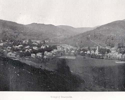
Downsville is a hamlet, census-designated place (CDP), and former village in the town of Colchester, Delaware County, New York, United States.[2] The population was 617 at the 2010 census.[3]
It is the site of the Downsville Bridge, a covered bridge, and the historic Union Free School. Both are listed on the National Register of Historic Places.
Downsville is named for Abel Downs, who had a tannery there.[4] The hamlet is located on the East Branch of the Delaware River. A dam on this portion of the river, at Downsville, was completed by workers paid for by New York City in 1954, creating the Pepacton Reservoir, which is part of the New York City water supply system. The Delaware and Northern Railroad ran south of town. There was a station on Depot Street.
Downsville Central School, located on Maple Avenue, serves families from the surrounding areas, including municipalities as far away as East Branch. Downsville Central School's colors are purple and white and their mascot is the Eagle.[5]
Downsville is located in the northern part of the town of Colchester, along Downs Brook just north of its confluence with the East Branch Delaware River. New York State Route 30 passes through the hamlet, leading southwest to the hamlet of East Branch at NY 17, and east along the Pepacton Reservoir to Margaretville. New York State Route 206 leads northwest from Downsville 10miles to Walton and southeast to NY 17 at Roscoe.
According to the United States Census Bureau, the Downsville CDP has a total area of 10.4sqkm, of which 10.2sqkm is land and 0.2sqkm, or 1.97%, is water.[3]